| |
|
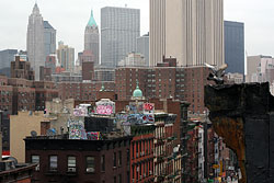
03 May 2008. View of the "Two Bridges" neighborhood from the Manhattan Bridge, with Knickerbocker Village in the background.
|
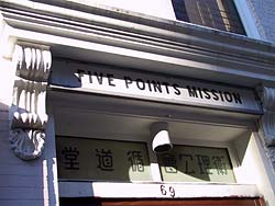 Five Points
Mission, 69 Madison St. Five Points
Mission, 69 Madison St.
The Five Points (map) was an early 1800's slum neighborhood located in the
area just north of City Hall around today's Baxter, and Worth Sts.
The Five Points was notorious for its human misery, and lawlessness. At the
center of the Five Points was the Old Brewery, a dilapidated old flop house
said to be the site of a murder a night for over fifteen years. In 1852, the Old Ladies Home
Missionary Society of the Methodist Episcopal Church purchased the Old Brewery;
eventually replacing it with the Five Points Mission.
In 1921, the Five Points Mission moved to its present location on
Madison Street, and today (since 1966) is home to the Chinese United Methodist
Church. [FN 1, 2, 3]. |
| |
|
Footnotes and resources:
1: The Five Points Site archaelogy dig (click on the "who lived at five points" link for MAPS).
2: A lithograph of the Old Brewery. from NYPL website.
3: CUMC page
For more resources, go to my links and resources page,
or the Five Points map.
Madison St New York Chinatown NYC Madison Street NY Manhattan map visitor maps tourist info information 紐約 中華街, 唐人街 ニューヨーク, チャイナタウン photo images photography photos Flushing Brooklyn china town pictures manhatan
|
|