A Journey Through Chinatown


Maps of Chinatown
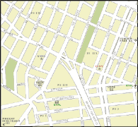
Map of Chinatown with transportation, churches, surveillance cams, banks and atms, etc.

Canal St Map includes food, shopping, and other area points of attractions.

Map of the Five Points a historic tour of New York's Sixth Ward that existed before Chinatown.
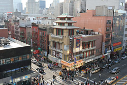
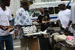

Photos
organized by street

Allen Street
 
Baxter Street
Bayard Street
The Bowery
Broome Street
Canal Street
Catherine Street
Centre Street
Centre Market Pl
Elizabeth Street
Market Street
Chatham Square
Essex Street
Misc Images
Chrystie Street
Grand Street
Mosco Street
Division Street
Henry Street
Mott Street
Doyers Street
Hester Street
Mulberry Street
East Broadway
Kenmare Street
Orchard Street
Eldridge Street
Madison Street
Park Row
 
 
Pell Street


organized by subject
Storefronts
2100+ stores and buildings
 
Historical Photos
including the Five Points
Chinese Vegetables


Other NYC Chinatown Information
Chinatown Directory
restaurants and shop listings
Links & Resources
useful links
Bookstore
Browse recommended titles on Chinatown, cooking, and NYC
Newspaper Articles
articles specifically about NY Chinatown
Image Usage Policy
 
About this Site
statement, history behind website
What's New?
changes, and additions
.


Visit Flushing Chinatown, and Brooklyn Chinatown.

纽约华埠 紐約 唐人街 中國城 華埠 地圖


© Copyright 2002-2013 by RK Chin. All rights reserved.
visit : rkchin home : photography : nyc chinatown :

Manhattan Chinatown New York City maps map photos images photography photo gallery