| |
|
You can obtain free Subway, and bus maps from any subway booth, library, or visitor center. Commuter rail maps (Metro-North, and LIRR) are on the back of each subway map. If you are not in NYC, you can send a self-addressed stamped business-sized envelope to MTA NYC Transit Customer Assistance 2 Broadway, Room D11.03 New York, NY. 10004 or call 1-718-330-3322, for 25 or more copies 1-646-252-6862, (fax) 1-646-252-6857. Digital commuter/transit maps & info:
RECOMMENDED: check your hotel concierge if they have the concierge map from nymap. grab a copy or two, it's a great map, and free. Free digital NYC & other Information
More free digital maps from various B.I.D.'s
December 2012
2010 edition
"This is absolutely one of the best maps of Manhattan. Rough Guide features a clean layout of Manhattan from Battery Park all the way up to 147th Street. Printed on tearproof, waterproof, flexible plastic material, the map is jam packed with culinary, shopping, and cultural landmarks along with subway stations, ferries, houses of worship, and even vantage spots where one can get the best views of various NYC landmarks. Even though packed with information, the map is surprisingly easy to read thanks to its clean design and use of legable san-serif fonts. The map even includes the restricted area near Chatham Square closed by the police after September 11, and remains closed today. In the back there is a special time chart indicating what time various shops and restaurants open, and close. There is also a mini map indicating all the major highways into the five boroughs, and small arrows indicating traffic direction." --rk chin
2006 edition.
"Borsch maps are jam packed full of information, yet easy to read and legible thanks to its clean modern layout and judicious use of colors and icons. On the main map, Manhattan is shown from downtown all the way up to 86th Street in 1:15000 scale with Subway stations pinpointed along with major landmarks, churches, and museums. The back is printed with 1:9000 scale focus maps of the financial district, and another one of midtown. There is also a 1:240,000 road map of the tri-state area. Easy to fold, and to store away, the maps are also printed on waterproof, tearproof, flexible plastic sheet (unlike the Rough Guide, this map uses a heavyweight plastic allowing you to mark it up with a china pen, then wipe off the marks when you are done." --rk chin
2008 edition.
"Borsch maps are jam packed full of information, yet easy to read and legible thanks to its clean modern layout and judicious use of colors and icons. On the main map, Manhattan is shown in its entirety in 1:15000 scale with Subway stations pinpointed along with major landmarks, churches, and museums. the map has insets for Midtown in 1:10000 scale, and downtown in 1:9000 scale. Easy to fold, and to store away, the maps are also printed on waterproof, tearproof, flexible plastic sheet (unlike the Rough Guide, this map uses a heavyweight plastic allowing you to mark it up with a china pen, then wipe off the marks when you are done." --rk chin
2001 edition. out of stock/out of print These have now been renamed Borch Maps.
Oct 29, 2008 edition.
"Hagstrom 5-in-1 is packed with information, and user friendly to boot. It features one large map of Manhattan from downtown all the way up to 132nd Street. In the back, there is a small subway map; a small focus map of lower Manhattan below Canal Street; a small focus map of West Greenwich Village; a focus map of midtown Manhattan with block by block listings of shops and businesses; and a small road map of the entire five boroughs. Details such as locations of landmarks, addresses, and a no-nonsense color scheme makes Hagstrom the best map you have have at half the cost of its fancier, and potentially less useful rivals. The two downsides are that this map is not laminated, and the map is somewhat unwieldy when you unfold it." --rk chin
2007 edition
"Pocket Pilot maps are smaller versions of the Berndtson maps. Measuring just 4x4 inches folded, and 11x24 inches unfolded, one can carry this map anywhere, and with ease. The map is printed on plastic sheeting. On the front side is a map of Manhattan up to 96th st along with small focus maps of Times Square, Lower Manhattan, and the New York City Subway. On the reverse is a highway map of nyc, a list of top 20 sights to see, and various facts, and listings." --rk chin View samples of this map here.
2010 edition
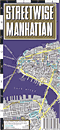
"I have seen many tourists and visitors carry this map around with them in NY. It really does one thing really well, provide you with a barebones map of New York without going into excessive detail that may increase the time it takes to look something up. Streetwise features a clean layout, and a highly readable typeface. Subway stations and landmarks are colorfully pinpointed on the map along with small arrows indicating the direction of traffic. The map is printed on laminated heavy cardstock, and folds up neatly when not in use." --rk chin Streetwise Downtown Manhattan
2010 edition
Focusing on lower Manhattan from the tip of the island, to Walker Street (one block south of Canal Street.) Streetwise Greenwich Village/Chinatown/Little Italy/East Village/SoHo/Tribeca
2009 edition
Focusing on lower Manhattan from Chambers Street to 22nd Street.
This is one of the better maps of lower Manhattan anywhere, and it's free. The map covers Manhattan from the Battery to Canal St. It displays a wealth of information of benefit to tourists, and residents alike from cultural attractions, historical streets, civic institutions, suggested walking tours, parks, green markets, subways, schools, ferries, etc. On the back of the map are postage-stamp sized photos of 300+ famous buildings, and attractions. The map was produced by Culture Now, in conjuction with the Lower Manhattan Community Council. Free maps are available at a few locations (I've seen plenty at at the info kiosk on the corner of Church St/Vesey, WTC. see their website for additional information. --rkchin
January 2001 edition
"This outstanding Broadway Playbill sized booklet, 64 pages in all, covers most of Manhattan only skipping East Harlem, and parts of Inwood. There is not much to fault these highly accurate maps containing landmark, shopping and entertainment information, except to say it is very colorful, informative, and detailed up to the point of information overload. The only one issue that can be a concern are the way Subway stations are marked, as red encircled "S"s with only the name of the Subway stop (not the subway line) listed next to it. To look up a subway station, one must refer to the included subway map. Also included in the guide is a map of the Bronx Botanical Gardens and Bronx Zoo, a map of Brooklyn's Prospect Park, neighborhood information, and a general calendar of events and festivals." --rkchin
"This is a nice map that complements DK's comprehensive guidebook to New York City. The heavily laminated map features Manhattan from the Battery/Bowling Green all the way up to 95th Street. The layout is clean, attractive, and extremely easy to read. Landmarks, subway stations, and other points of interest are denoted on the map as colorful icons. The back of the map features helpful shopping, and neighborhood information along with a guide to NYC transportation options. It shows you how to drive in New York with photos of street signs, and traffic tips. There is a section on how to flag a taxi, how to read the taxi meter, and what to do in case of a dispute--involving reading the hack license and obtaining a receipt. Subway and bus riders are shown how to read a subway map, how to use a Metrocard, how to read the route information on a bus, and other tips along with plenty of photos and illustrations. Excellent." --rkchin
April 2001 edition
"This is unique guidebook/map-in-one covers Manhattan up to 125th St on eight mini-maps which separately fold out for a larger view. Essential neighborhood information is provided in guidebook format (with telephone number and address) these include restaurants, shopping, theaters, bars, and mustn't miss landmarks. A subway mini-map, and a list of hotels is included as well." --rkchin
2003 edition
"Printed by Michelin guides, Cognoscenti's travel-saavy maps recommend the best shopping, culinary, and cultural attractions Manhattan has to offer. The map features a clean, contemporary layout of the New York City from the Battery all the way up to 112nd Street. Recommended listings are numbered on the map in large readable font, and color coordinated according to subject. The index lists each entry along with its address, phone number, price-range, and a mini-review. Only the best restaurants, hotels, spas, stores, and museums are listed. Cognescenti maps are printed on tearproof, waterproof, flexible plastic material." --rkchin
2007 edition
"MapEasy are fantastic, and beautiful 3-D maps suitable for framing, really. Each map is entirely hand-drawn, annotated with small illustrations of landmarks, historical tidbits, and filled with color-coded listings of many neighborhood shops that a resident, not just a visitor would find useful. It is a map, and tourguide in one. There is one main map, and in the back, a series of mini-maps focusing on various areas of interest along with driving directions, suggested itineraries, and more. The maps are printed on tear resistant, water resistant flexible material for long lasting quality. MapEasy's "Midtown" map shows the area between 33rd and 59th st." --rk chin
2008 edition
This review is for the early 2002 edition. It featured the Twin Towers on the cover, and the World Trade Center area in detail. The 2003 edition, with the Statue of Liberty on the front cover, has Ground Zero instead. The one downside of MapEasy's Lower Manhattan map is its definition of "Lower Manhattan" being the area below Chambers Street--which you should just call the Financial District. The 2008 edition is updated with new cover, and new landmarks and buildings beautifully hand-drawn in 3-D.
2008 edition
The area from 59th to 89th Street.
"This map features a clean layout of Manhattan from the Battery all the way up to 132nd Street. In the back, there is a mini subway system; a mini Manhattan bus map; and mini map of the five boroughs. An index of streets and sights, a list of eating and shopping recommendations, and a list of the top ten things to do in New York City is also presented. Like Streetwise, IMAP, and others, this is an accordian style map printed on laminated heavy cardstock." --rkchin
"Similar to Streetwise, this laminated cardstock map neatly folds away for quick storage. In IMAP "New York", only the borough of Manhattan is featured, with downtown Manhattan on one side, and Manhattan up to 110th street on the other. In detail, the New York map is slightly difficult to read because most streets are rendered as thin pen strokes. Icons of museums, hotels, attractions, and transportation facilities are noted in colorful detail. IMAP comes with a mini guidebook, and a small button compass." --rkchin Geographia Quickfinder Midtown Manhattan
"One side features an empty street grid of Manhattan from the tip of the island all the way up to 92nd Street. Only the names of landmarks, hospitals, and apartment buildings are listed on this map, there are no tourist attractions. On the reverse is a map of midtown from 30th-64th Street with shops and businesses mapped out block by block. The map features a clean readable layout, and it is laminated in heavy plastic, unlike those other maps that are printed on laminated heavy cardstock." --rk chin
"National Geographic sometimes makes good maps, but it depends on the subject. When it comes to tourist maps such as this one, it is a mixed bag. This map features a large map of Manhattan up to 86th Street in 1:6500 scale, along with smaller focus maps of midtown, downtown, the area airports, and a regional highway map. Major landmarks on the map are marked with a colorful icon along with the name listed right next to it. The map is laminated in plastic." If you ask me, the best map of New York City would be the National Geographic map that supplemented the September 1990 edition of the magazine. That map featured the entire island of Manhattan in accurate detail along with locations of significant and obscure landmarks, history, and a trail map of the old New York Albany Post Road from Manhattan to Tarrytown, NY. --rkchin
Unique, small (5.0 x 3.75 inch, 130 x 95mm) popout map covering downtown Manhattan, with small maps of New York Harbor, Midtown Manhattan, a subway map, and Greenwich Village.
"I didn't like what I saw when I found this map in the bookstore. This map is very basic, containing 5 maps of lower manhattan up to 8th st. Each map is basically a colorful barebones street grid with not much else. There is a separate nyc subway mini map, and an index of major landmarks listed. The map is printed on laminated heavy cardstock, and it folds up quickly like Streetwise, IMAP, and others. You can do better by printing your own map of Manhattan with what you want on it rather than staring at a barebones map with almost nothing on it." --rk chin On Your Own Manhattan Street Map
On Your Own Brooklyn Street Map
On Your Own Queens Street Map
"This slender pocket-sized directory strips New York City down to its essential shops, businesses, and landmarks. Organized by subject, you lookup the name of the place you want, then find its number on the map. Consulates, restaurants, subway stations, art galleries, theaters, and more are listed." --rk chin
not listed at amazon.com USA, Canada, or UK "This is another quick-fold barebones map of Manhattan printed on laminated heavy cardstock. The layout of this map is clean and modern featuring a pale blue and gray color scheme. There is not much on the map except for the locations of major landmarks, museums, and subway stops. In the back is a short narrative mini tour through thirteen selected neighborhoods, their character, and highlights." --rk chin Red Map SoHo
This map covers the small square area from Grand Street to Houston Street, and west of Broadway. All shops and restaurants are mapped out block by block. Red Map Midtown
This map covers a tiny square area of Midtown from 41st Street to 59th Street with all shops and restaurants mapped out block by block.
not listed at amazon.com USA, Canada, or UK "Printed on laminated heavy cardstock like Streetwise, IMAP, Red Map, and others, this map is basically a street grid of Manhattan with all the major landmarks, churches, hospitals, and museums listed on it; there is not much else. The one feature that distinguishes this map from most others is the fact that it shows ALL of Manhattan from the Battery all the way up to Spuyten Duyvil. The one minor annoyance of this map are the way subway stops are indicated, as blue dots with a M in the middle--the MTA logo--the subway line is not indicated alongside it. The back of the map, however, features a mini subway map, and a map of the theater district." --rk chin
Spiral-bound atlas (11 x 8 inches) of the 5 boroughs. brooklyn, bronx, manhattan, queens, and staten island.
2008 edition
"This is the driving bible that NYC taxi drivers carry around with them when they need to look up some street they don't quite know where it is located. Sometimes it is used as an excuse when they are taking you on the 'scenic route' around town before charging you triple what is supposed to cost to go from destination A to B, but I digress. This atlas is excellent, and shows every street in every borough of New York; Bronx, Brooklyn, Manhattan, Queens, and Staten Island. There is little in the way of tourist attractions, and landmarks, so tourists may not find this atlas too useful, except as an accurate road map around town. There are several versions of this excellent atlas. The spiral bound pocket version is the smallest, and smaller does not mean tinier maps; it means the full-sized maps are cut smaller to fit into this book resulting in more pages to scroll through. Pages are laminated so you can simply wipe pages clean should you spill coffee on them." --rkchin
2002 edition
"This slender atlas is basically a Manhattan street grid with street names, address blocks, and building names listed on it. Information is a little difficult to locate because--thanks to the slender nature of this atlas--the maps are crowded together, and a capitalized serif font is used. To make things a little easier, an alphabetical index of institutions are listed in the back. The Tauranac is not a visitor/tourist map, rather, it is an atlas for those who need to navigate through Manhattan, and to locate specific buildings and institutions that are usually not listed on other maps. The atlas also includes a subway and bus map, but the way it is drawn makes it difficult to read." --rk chin |
|
NYC Chinatown Index |
Manhattan |
Flushing |
Brooklyn |
Links & Resources |
What's New Storefront Photos | Historical Photos | Bookstore | Directory | Image Usage Policy | E·mail |
|